November 4th - Road trip down the south end of Lake Mead

 |
| Lots of people fishing Las Vegas Bay. |


 |
View of Las Vegas Lake. |
 |
| Boulder Beach |
 |
| Another view of Boulder Beach (No sand here!) |


 |
| Another dry boat launch. |


 |
| Old rail tunnel, now part of a trail to Hoover Dam. |


 |
| Driving across the Hoover Dam |


Absolutely
stunning. Today Ray is going to go back and walk the dam so stay tuned for
more pics. I am suffering with plantar fascitis in my right foot, so it's ice
for me today.
November 5th - Ray's Adventure - seeing the Hoover Dam on foot
Yesterday
Ray went back by himself to explore the Hoover Dam. He's wanted to see this dam
in person for 30 years so now he can strike it off his bucket list!
 |
| Very impressive |
 |
Approach to the Hoover
Dam          Next it was off to the Memorial Bridge for some more shots.          |
Took the drive south via Henderson and then up to Red Rock Canyon. What a lovely drive. Ray was positively vibrating once he saw the Aztec Sandstones. Look at all the Joshua Trees. Elevation here is about 3700 feet according to the park flyer.


The first viewpoint was Calico 1. Unbelievable colour. There were people rock climbing on the cliffs here and at Calilco 2. The parks people put in permanent clips into the rock walls for climbers. These cliffs are actually petrified sand dunes.


 |
| The spots are all gum |
Next stop Calico 2. This was busier with climbers at the time but Ray did not capture them. (I was looking through binoculars from the car.)


| Surprisingly, most of the viewpoints had parking for about 30 cars and they were all very busy. This picture is High Point Lookout. |


 |
| La Madre Mountain |


Most of the viewpoints have washrooms and a couple, covered picnic areas. We should have brought our lunch. Oh well. At the end of a lovely drive we stopped for lunch at BJ's Restaurant and Brewhouse for a wonderful hand thrown pizza. They had the best craft beer we've come across yet. We will certainly keep our eyes open for other locations on our travels.

 |
| Great ambiance, great pizza, great beer and great company. |


On to
new adventures tomorrow.
November 6 - 9th - Valley of Fire (1)
I am way
behind blogging as we have had no cell service for a week.
November 6th
We left Government Wash yesterday and drove up the
highway for an hour to the Valley of Fire. We decided to go with the electric
and water hookup so I could run a few loads of laundry and Freya could stay in
air conditioning if necessary while we toured the park. The $20/night plus $10
for electric includes park entrance fee, sani-dump, potable water and 50amp
electric. The bathrooms are clean and they even have showers. The views from
the campsites are glorious. Each spot is well spaced from the next, has its own
covered picnic table, fire pit and hibachi grill. The only issue for us was the
spot I chose (which had the best view in my opinion) was quite unlevel back to
front so we are still a little tipped to the rear after levelling as best we
could. Freya enjoys running through the small bushes in front of us chasing the
stick in the soft red sand. Great for her sore paws after the boulders at
Government Wash. We have satellite TV but no cell coverage here. They have a
second campsite further down the road with no services except water but the
bathrooms are pit toilets and they smell for which you pay the same $20/night.
They did however, have some very secluded spots for smaller RV's that were
awesome. Here are some pictures of our spot. Every time you see something different
in the rocks.


 |
| Campsites with the most amazing rock features |

 |
| Honeycombs |

 |
| A campsite with arches |

 |
| Looks like a Dragon's Head |
First thing this morning at 5:45 am Ray was off to catch the sunrise on some of the viewpoints. A few of the blogs I follow had some amazing pictures of this area with the sun setting or rising. We were awake anyways as the time change always takes Freya and I about 2 - 3 weeks to adjust. (Some of his pictures did not capture the colour as well as he would have liked so he will go out again earlier another morning i.e. 5:00 am instead of 5:45 am.)

 |
| Scaffolding to get up to see the petroglyphs at Atlatl Rock |
Atlatl
Rock: Outstanding examples of ancient Indian rock art, or petroglyphs.


 |
| Hole in rock just below the petroglyphs |
 |
| Arch Rock |
Some golden light pictures at the Seven Sisters Picnic Site. The are seven pillars of sandstone surrounded by sand.


 |
| Cheese! |


 |
| Balancing Rock |
 |
| Heading back towards the Visitor's Centre. |


When we
got back, I got busy with one more load of laundry, made cookies and baked 2
loaves of bread since we have power to keep Ray's sweet tooth happy.

Valley of Fire (3) - 2014-11-12 16:17
November 8th


The next
place we checked out was "Snowbird Heights" on hilltop overlooking
the town of Overton. There is lots of room to boondock for free, but it pretty
much is like a gravel pit right next to the highway. Most of the views are of
gravel mesas with only a sneak peak of Lake Mead. There are a handful of sites
on the other side of the highway that overlook the red and white rock mountains
that would be better. It would be okay for a stop travelling through or a cheap
place to stay to visit the Valley of Fire if you did not want to pay $20-$30
per night and only pay the $10 entrance fee. The next place we stopped was the
Overton Wildlife Management Area, a few miles just outside the town. It
appears to be a hunting facility with duck blinds etc. They had about 6 large
separate campsites with a fire pit, hibachi grill and covered picnic table on dirt/sand
(great for Freya)and all for free for eight days. This definitely would be an
option for a few days. They also have a covered picnic area.
The Overton Wildlife Management Area (WMA) is
located in the delta region where the Muddy and Virgin rivers flow into Lake Mead (although most visitors only see the Muddy
River side). The WMA has extensive, seasonally flooded marshes, saltcedar and willow
thickets, honey mesquite and screwbean mesquite thickets, a few
big cottonwood trees, grassy fields,
and several ponds with different depths. Much of the time spent birding here
will involve trying to get little birds, hiding in the thickets, to show
themselves. Open to birding as long as the short hunting season is closed. This
is the easiest place in Southern Nevada to see Wild Turkeys, and it is a
great place to see waterfowl and wading birds in season.
Here is a picture of a rabbit that I saw off the
road. We also saw a roadrunner but he took off too fast for me to get a
picture.

A few
miles down the road was the small town of Overton. The road in widens to 4
lanes which seems to be a bit of overkill as there are not too many businesses.
We filled the car up with gas at the only gas station in town. Their diesel
prices were great at $3.47/gal in the middle of nowhere! The grocery store,
Lins, was a surprise. Lots of variety, fresh produce, fresh meat and a fresh
fish counter, bakery, deli and liquor etc. I was able to get a new propane tank
(trade your empty one for a full one for $18.99) and some firewood. Yeah. They
even had a special for Friday and Saturday of smoked pork baby back ribs that
were made in a little trailer outside the store as you walk in. $15 for a full
rack and $8 for a half rack that were still hot. What a deal. I surprised Ray
with the ribs and cold beer so we stopped back at the picnic area at the
Wildlife park and ate lunch.
We drove
back towards Lake Mead after lunch to check out another boondocking area called
Stewart's Point. There are not many spots for our "beastly size" that
were anywhere near the water. All of the roads leading down to the water were
very soft and rough. Although the car
could make it there would be no way that we would take the coach. We did let
Freya go in for a swim as it was 82 degrees out.


Coming back to camp at the Visitor’s Centre there was a car show winding up so Ray snapped a few pictures. Apparently, this was not well attended as there was a bigger show in Vegas happening at the same time.


Back at
camp I tried the hibachi and barbecued chicken with briquettes. It turned out
great with coleslaw. We also had a campfire and enjoyed the evening (part of it
anyways as it seems by 9 pm we need to get ready for bed after being outside in
the heat all day.)
To recap we would only stay at Government Wash or the
Valley of Fire or at the Overton Wildlife Management Park if we came back to this
area again. Our first choice would be in the Valley of Fire campsites though.
Had a shower there as I had filled the grey from the laundry, and it was 25
cents for 5 minutes. They were clean and water pressure was pretty good.
November 12th - Valley of Fire (4)
November 9th
Sunday morning Ray was up at 5am so he could go on
the walk to "The Fire Wave" with Freya to get some pictures. This
particular rock/hill is the most widely published picture of the park so he
wanted to see if he could get the picture showing the colours. Of course, you
can only get the colours up to an hour after sunrise or an hour before sunset.
When Ray came back, he said it was the best thing he had ever seen, it felt
spiritual. He took so many pictures of this that it will be hard to pick which
ones to blog.


 |
| Notice the full moon. |


A couple
from Aldergrove came over to say hi, Reg and Marie, to pick our brains
regarding wintering in the states. Reg has been following different people's
blog and asked to have the details for ours. We had a lovely chat for awhile
before they left on their way. They only have 3 weeks so see as much as they
can before going back home as they have racing horse boarding stables that
keeps them extremely busy.

After
that we had a quiet afternoon, with ice on my ankle and Ray's back. He paid for
going on the walk but said it was worth it to see the magnificent rock
formations up close. Tonight we are in at dark (4:30) to relax to get ready to
move on tomorrow. We are missing the Vegas Strip this time as well, as my ankle
cannot stand up to all of the walking.
November 12th - Burro Creek BLM
Monday, November 10th
We left Valley of Fire and made our way down the I-5
through Vegas and then down Highway 93 to a BLM camping area called Burro Creek
BLM. $14/night but you have the availability for water, sani-dump and garbage,
also flush toilets but again no cell service just satellite. Quite a cute place
and there was even some water in the creek with lots of sand for Freya to play.
The day was longer than we anticipated, so we were both pretty sore by the time
we got there, my foot and Ray's back. We minimally set up so tomorrow would be
an easy go into Phoenix and get into a Tiffin dealer to order up the parts we need
for the jacks and the side mirror. Once we find out how long it will take to be
seen, order parts etc we will be able to determine in which direction we will
go for the next month.
 |
| Home for tonight. |
 |
| Looking up at the Burro Creek Bridge on Highway 93 |
 |
| I'm going in! |
 |
| Lots of soft sand for Freya to chase her ball in. |
 |
| First close-up picture of a Joshua Tree |
November 12th - Burro Creek BLM to Lost Dutchman State Park
On our way to the Lost
Dutchman State Park we stopped at LaMesa RV, a Tiffin Dealer, to arrange for
the work to be done on the coach so they could order the parts from Tiffin. We
have an appointment for repairs on December 2nd. (I find that so hard to
believe that December is in 2 1/2 weeks!) So for now we will stay here for 3
days and I will rest my sprained ankle so it finally gets better and then we
will stay in the Phoenix/Tuscon area for the next 3 weeks until our
appointment.
Here are a couple shots taken yesterday afternoon.
This is a beautiful campground and very busy. We were only able to have this
spot for 3 days as they are solidly booked this weekend. $25/night for water
and 50amp.
Lost Dutchman State Park at the base of the Superstition Mountains.

I
cooked barbequed hamburgers on the outdoor grill as the sun was setting.
Gorgeous.
 |
| Anyone notice the reflection? |
Lost Dutchman State Park - 2014-11-13 09:24
We had a fairly quiet day yesterday after 2 days of travel. Ray did the shopping while I rested my foot and got the blogs up to date. What a guy, came home with a dozen red roses and an ankle brace! Shortly after he got back, out came the camera for pictures as this is such a pretty park with lots of interesting plants, views etc. The sky was spectacular.
This ocotillo is just about ready to bloom.

 |
| The biggest Cholla I have seen! |
 |
| Praying Hands |
 |
| The large flat peak is called "The Flatiron" at 4861 feet. |
 |
| Looks like a mouth with teeth to me! |
 |
| Happy Hour ... what a view! |
 |
| Sun starting to set. |
 |
| Ray saw these quail this morning walking Freya. |
November 14th - Lost Dutchman to Snyder Hill BLM
Last night we ate dinner with friends Malc and Kathy
who stay at Queen Valley. They took us to Elvira's Cantina in Apache Junction.
Wow, the Mexican food was great. (I was not a fan normally, but loved their
flavours.) Unfortunately the pictures we took did not turn out. so here are a
few from their website. The decor is wonderful and very friendly staff.
Actually the table on the left by the wall is where we sat.


Next stop was a BLM place called Snyder Hill just outside of Tucson, 8 miles towards Ajo, for the night. Unbelievable so close to Tucson. The site did have some rubby campers though.
 |
| Our home for the night. |
 |
| With a fantastic sunset. |

Anyways, we will head to Tombstone tomorrow and stay for several days and take some downtime ... we will be in a hot tub by 3pm!
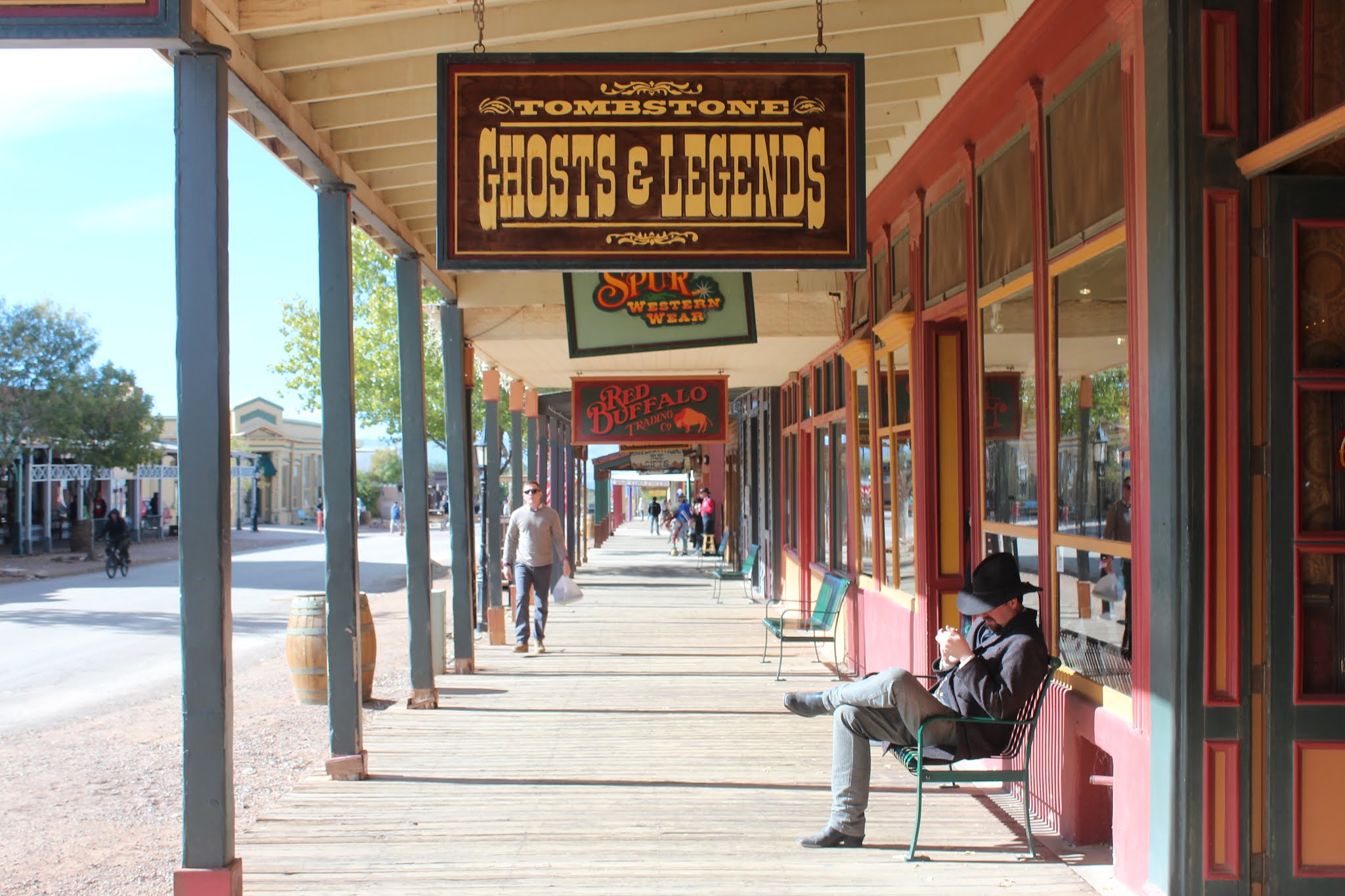
November 16th - Tombstone
Arizona


It was time to take a couple of days off and just sit at home, relax, do laundry and sit in the hot tub. Ray's back has been getting steadily worse with covering more of my chores with my sprained ankle, so this seemed to be a good place to stop with lots of fantastic views. The best part is the park is quite empty at the moment until after the American Thanksgiving next weekend so no wait at the hot tub etc. Pretty much have the pool and hot tub to ourselves. It is really quiet here at night which is wonderful as well.
Once we sit still for a couple of days it will be time to go into Tombstone and see the OK Corral daily shootout! Ray will visit the Kartchner Caverns (I am still recovering with my sprained ankle and cannot walk for the tour). There is also Bisbee to investigate so lots to see this week.
Ray spent his birthday yesterday in the hot tub and then sitting in the sun in his lounger with a margarita.
This morning we thought we had dreamt the same dream .... COWS! were we back in Merritt?
Nope they were just on the other side of the fence in the thick brush!


November 18th - Tombstone
Tombstone was founded in 1877 by a prospector
named Ed Schieffelin. Ed was staying at
what was then called Camp Huachuca (wa-chu-ka) as part of a scouting expedition
against the Chiricahua (chir-i-cow-uh) Apaches. During his time there he would venture out
into the wilderness "looking for rocks", all the while ignoring the
warnings he received from the soldiers at the camp. They would tell him, "Ed, the only
stone you will find out there will be your tombstone". Well, Ed did find his stone. And it was Silver. So, remembering the words of warning from
the soldiers, he named his first mine The Tombstone.
It wasn't long before word spread about Ed's
silver strike. Soon prospectors, cowboys, homesteaders, lawyers, speculators,
gunmen and business people flocked to the area in droves. In 1879 a town site
was laid out on the nearest level spot to the mines, known at that time as
Goose Flats, and was appropriately named "Tombstone" after Ed
Schieffelin's first mining claim.
By the mid 1880's Tombstone's population had
increased to around 7,500. This figure counted only the white male registered
voters that were over 21 years of age. If you take into account the women,
children, Chinese, Mexicans and the many "ladies of the evening" the
estimates are that the population was between 15,000 and 20,000 people. At its
peak, it is said to have been the fastest growing city between St. Louis and
San Francisco. There were over one hundred saloons, numerous restaurants, a
large red-light district, an even larger Chinese population, schools, churches,
newspapers, and one of the first public swimming pools in Arizona (which is
still used today).

There were a few theaters in town, the most
famous of them being Schieffelin Hall and the Bird Cage Theatre. Schieffelin
Hall was where the "respectable" people in town went for
entertainment. It opened in June of 1881 and was built for the people of Tombstone
by Ed Schieffelin's Brother Al. It is the largest standing adobe structure in
the southwest United States and was built to be used as a theater, recital hall
and a meeting place for Tombstone Citizens. Wyatt and Morgan Earp attended a
performance there the evening that Morgan was killed by an assassin's bullet.
It is still in use today by city government and civic groups.
The Bird Cage
Theatre is another story. It was a saloon, theater, gambling hall and brothel.
Legend has it that no self-respecting woman in town would even walk on the same
side of the street as the Bird Cage Theatre. It opened its doors on Christmas
Day 1881 and ran 24 hours a day, 7 days a week, 365 days a year until closing
its doors in 1889. In 1882, The New York Times reported, "the Bird Cage
Theatre is the wildest, wickedest night spot between Basin Street and the
Barbary Coast." Evidence of this can still be seen in the 140 supposed
bullet holes that have been found in the walls and ceiling. The Bird Cage was
named for the cage style crib compartments suspended from the ceiling. It was
in these "Bird Cages" that the "ladies of the evening"
entertained their customers. The story goes that they were the inspiration for
the song, "She's only a bird in a gilded cage", which was quite popular
during the early 1900's.

***In 2005 the Bird Cage was filmed with Ghost Hunters and they believed it to be the most haunted place in the US they had filmed.
Ray and
I decided to start out with the 25 minute Trolley Tour, to see as much of the
town as possible as my ankle is still recovering although much better, There
were a lot of people walking around in period costumes.
 |
| Our Trolley |
 |
| The Courthouse |

 |
| This is the first church. |
 |
| The Good Enough Mine (It produced millions of $ in Silver). |
 |
| Episcopal Church |
 |
| "Texas John" Slaughter house (a feared lawmen who founded the "Slaughter Ranch) |

 |
| In period costume but using a cell phone?????? |
 |
| The haunted Buford House (Lover's quarrel - almost murder/suicide) |
 |
| Wyatt Earp's House |


The
ticket also included a 25 minute comedy gunshoot out as well. They were so
sappy but injected a bunch of "today's" stuff as well such as when
her gun fell apart she said "it must be an Ikea Model", some assembly
required!" I laughed so hard a couple of times that tears were running
down my face, a good start to the day. It was cold outside though at a balmy 4
or 5 degrees.


 |
| They have a beautiful imported 22 foot solid wood bar. |


After
the show we took a few pics of their museum. This is a picture of the original
"phaeton" which our motorhome is named after.


So back in the car and off to Boot Hill Cemetary.

 |
 |
| Dragoon Mountains in the distance |
 |
| Ok Corral Victims |
November 18th - Cochise Stronghold Arizona
We left Tombstone Territories RV Park this morning. The short Kartchner Cavern tour Ray wanted to take was booked up for a couple of days and Bisbee only opens Thurs-Sun and it's only Tuesday. As our 3 days at the Passport America rate was done and at $40/night (plus electricity) after that, the facilities weren't worth it. We did enjoy the hot tub and pool though. So off to another adventure.
I found a restaurant and RV Park, and I use the term
loosely, (it's actually called Sandys Restaurant and RV Park) at Pearce,
Arizona which is just on the road to Chiricahua Monument. Full Service, 50 amp
water and sewer for $25/night. Apparently they have a rate for $75/week which
we will take them up on tomorrow. The view out the front window is pretty good.
After minimally setting up and a wonderful lunch at
the diner we were off to see the Cochise Stronghold as it was only a short
drive away. Ray watched a lot of westerns as a kid and was quite interested in
seeing this. (Ray speaking here: what guys, at my age, haven't heard about
Cochise and the Apaches?)
Here is an excerpt from the history files on google.
Cochise Stronghold is located to the west of
Sunsites, Arizona in the Dragoon Mountains at an elevation of 5,000 ft. This beautiful woodland area lies in a
protective rampart of granite domes and sheer cliffs which were once the refuge
of the great Apache Chief, Cochise, and his people.
This rugged natural fortress was, for some 15
years, the home and base of operations for the famed Chiricahua Apache Chief,
Cochise. Cochise and about 1,000 of his
followers, of whom some 250 were warriors, located here. Sentinels, constantly on watch from the
towering pinnacles of rock, could spot their enemies in the valley below and
sweep down without warning in destructive raids. No man, woman or child within a hundred miles
was safe from these attacks.
Born in present-day Arizona, Cochise led the Chiricahua band of the
Apache tribe during a period of violent social upheaval. In 1850, the United
States took control over the territory that today comprises Arizona and New
Mexico. Not hostile to the whites at
first, he kept peace with the Anglo-Americans until 1861, when he became their
implacable foe because of the blunder of a young U.S. Army officer, Lt. George
Bascom. In that year, Cochise and
several of his relatives had gone to an encampment of soldiers in order to deny
the accusation that they had abducted a child from a ranch. The boy was later
proved to have been kidnapped by another band of Apaches. During the parley,
Cochise and his followers were ordered held as hostages by Bascom, but Cochise
managed to escape almost immediately by cutting a hole in a tent. Bascom later
ordered the other Apache hostages hanged, and the embittered Cochise joined
forces with Mangas Coloradas, his father-in-law, in a guerrilla struggle
against the American army and settlers. The capture and murder of Mangas Coloradas
in 1863 left Cochise as the Apache war chief.
The U.S. Army captured him in 1871 and prepared to transfer the
Chiricahua to a reservation hundreds of miles away, but he escaped again and
renewed the resistance campaign. The following year after negotiating a new
treaty with the help of Thomas Jeffords, his only white friend the band was
allowed to stay in their homeland.
The portion of
the Butterfield Stage Line run from Fort Bowie to Tucson crossed just off the
northern tip of the Dragoon Mountains.
This line was a favorite target of Cochise's warriors, they killed 22
drivers in a 16 month period. The
Butterfield Stage Line established a station stop on the north end of the
Dragoons in 1858. It was called the
"Dragoon Springs" station due to the natural springs located
there. A massacre occurred at this site
on September 8, 1858. On October 5, 1869
a Col. John Finkle Stone, the 33-year-old president of Apache Pass Mine, near
Ft. Bowie, headed back to his home in Tucson aboard a mail coach. He had an
escort of four soldiers. When they approached the abandoned stagecoach station
at the north end of the Dragoon Mountains, a group of Apaches came out of a
gully and hit them fast and hard, killing everyone. (The ruins of the station stand today although
the springs were rerouted by mother nature in an earthquake in the late
1800's.)
Cochise is
reputed to have been a master strategist and leader who was never conquered in
battle. For ten years Cochise and his
warriors harassed the whites by raiding lonely ranches and attacking
stagecoaches and miners. Cochise
retired. He died peacefully on the newly
formed Chiricahua reservation in
1874. His son, Taza succeeded him as
chief. Upon his death, he was secretly
buried somewhere in or near his impregnable fortress. The exact location has never been revealed or
determined.


Here are some pictures of the Cochise Stronghold.

 |
| Old house but new window frames |


 |
The "Littlest Hobo", Freya |


November 19th - Chiricahua National Monument
We drove up to the Chiricahua Monument yesterday. Unbelievably
gorgeous. I was able to do 2 short walks with my ankle ... slow and steady ...
as my runners will not fit with my ankle brace so I was wearing my rubber
slipons, and let Ray go ahead to take pictures. Here is a bit of an excerpt
about the mountains. (Ray took a total of 257 pictures so it is taking me
awhile to edit and pick the best!) There apparently are lots of birds and
animals in the park but I only saw 2 deer, 1 squirrel, 2 lizards, 1 Mexican Jay
and what I think is poop from ???? skunk, that's what the area smelt like.
(they have 4 types in the park!) Of course I did not have the camera.
In the far southeastern corner of Arizona are
the beautiful Chiricahua Mountains, one of several “sky island” mountain ranges
surrounded by expansive desert grasslands. The Chiricahua Mountain Range is an
inactive volcanic range twenty miles wide and forty miles long. It forms part
of the Mexican Highland section of the Basin and Range Biogeographical Province
and rises up dramatically from the valley floor to over nine thousand feet,
cresting in a series of uneven, volcanic looking peaks. At the northern end of
the range is an extraordinary area of striking geological features and enormous
biodiversity. Tucked deep into these steep, forested valleys and beneath the
craggy peaks are the remains of violent geological activity that continued for
many millions of years—the pinnacles, columns, spires and balanced rocks of
Chiricahua National Monument. The Apaches called this place 'The Land of
Standing-Up Rocks', a fitting name for an extraordinary rock wonderland. Early
pioneers in the late 1800s sensed the unique beauty and singularity of the rock
formations in the area. They were instrumental in persuading Congress to
protect this ‘Wonderland of Rocks’, so much so that in 1924 the Chiricahua
National Monument was created.
We
stopped at the Visitor Centre, picked up the park map, watched a short video
and then started up the 8 mile scenic drive to the top of Massai Point with
it's 360 degree view.
Before leaving the park there is an historic ranch site called the Faraway Ranch (the original people from Sweden who settled here). These people were instrumental in creating the park in 1924. We didn't hike in to see it ... our neighbour did a couple of days ago and these are Paul's pics.


 |

Next is
the China Boy.... did not look like anything to us but here it is.

Up and up the road climbed overlooking the San Simeon Valley which was
once fertile and now just scrub desert due to lack of rain. Harris
Mountain is in the middle of the Valley below.


Up and up to an elevation of 6870 at Massai Point. They have a short nature trail around the top and a little exhibit pavilion. From here you realize the extent of the volcano and the huge rim (the circular mountain ridge in the distance below.) They say this explosion was 1000 times bigger than Mount St. Helen's!
 |
| Look past the lower ridge at the bottom of the picture... The whole
circular ridge past that is the rim of the volcano. |
From this height above the Sulphur Springs Valley (to the west of the Chiricahua Mountains) you can see across to the Cochise Stronghold we just visited.


 |
| If you look closely just below the eyebrow is a 150' fir tree for an eyelash. |


The Echo Canyon Grotto was next on the list, a .5 mile trail in and out. Ray started off without me as I did not know how my ankle would hold up. I just went slow and carefully over the rocks and managed to do half the thing. What views and I'm so glad I persevered and was able to experience this cool place. Here are some pictures from the trail.


 |
| The top right rock looks like the float we saw years ago in the Disney below |


Next we drove down a little way to the Echo Canyon view point and went
to the base of the Sugarloaf Mountain and looked out towards the canyon we
followed up showing the grasslands and the Dragoon Mountains with the Cochise
Stronghold.

Sugarloaf Mountain on
the far left. His pants are a "little big" due to all his
camera lenses stuffed in his pockets!
We
decided to stop for lunch at Echo Canyon (table was too far for my ankle), then
tried Sugarloaf but the one picnic table is beside the outhouse, so we made our
own spot. Simply Gorgeous.

Well,
enough of this and back down the mountain and home to our campsite and rescue
the dog. As we left the park, Ray looked back to see the sun on the rhyolite
structures and took a couple of pictures. The amazing part is we noticed
none of this when we arrived this morning as the sun was behind the mountain
and all of this below was in shadow. This park is one of our new
favourite places!

Our RV Park neighbour did the long hike from Massai Point down to the Visitor Centre. He took some amazing pictures:


November 21st - White Water Draw
After
lunch yesterday we decided to take the short trip to White Water Draw to see
the "free camping" spots that they have where you can drycamp for 3
days while experiencing all of the birds. I'd planned to camp there on our
way from Tombstone, but after checking out the weather and finding that it would
be below freezing this week we decided to stay at Sandy's at $75 for the week
with 50amp service, water and sewer, also central to everything else we would
like to visit.
White Water Draw is a beautiful spot for birding.
They have 3 designated campsites with table and firepits and a lovely walking
trail all around the marsh, even a viewing platform with scopes. There is
supposedly 30,000 cranes there at this time of year but there were several
thousand only and they were way across the water. So unless you blow up one of
Ray's pictures, we were too far away to get a good shot. Here are a few of
the pictures Ray took today.
 |
| This gentleman was giving me instructions of where to see the Vermillion Flycatcher on the other side. |
 |
| Loggerhead Shrike |
 |
| Egret |
 |
| Vermillion Fly Catcher |
 |
| Camping area |
Driving back to camp we saw fields of cotton. They sure look like snow up close!
We saw a roadrunner on the way back home but Ray could not get the camera operational before it took off. They are so fast! Here is a picture that he did not take!


Another interesting adventure. We will sure keep White Water Draw on the list for a spot to stay for a couple of days next time we are in this area. It was also several degrees warmer with no wind compared to where we are staying and only 30 minutes away.
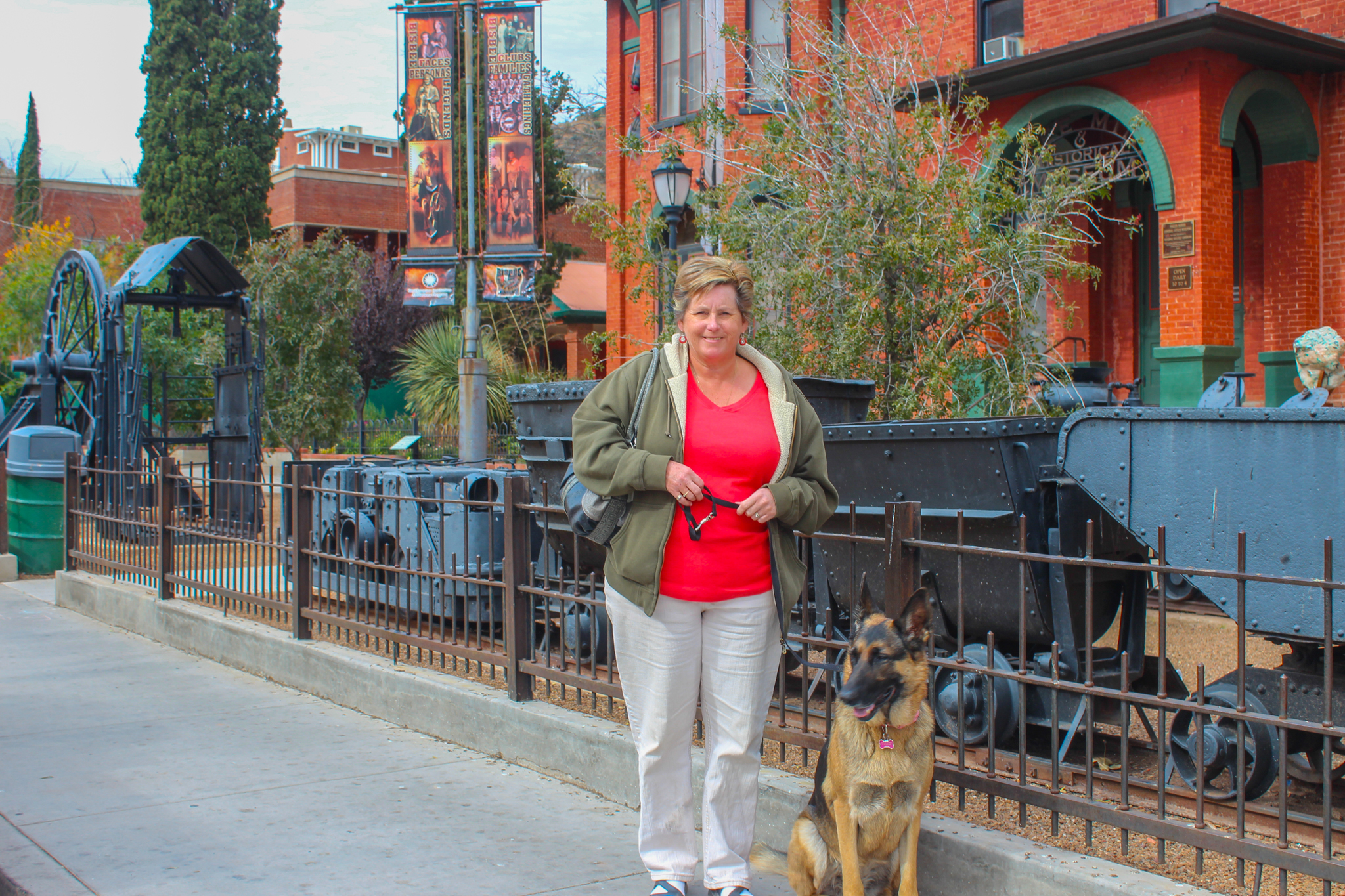
Bisbee Arizona - 2014-11-22 08:36
Bisbee, 90
miles southeast of Tucson and nestled amongst the Mule Mountains, is the
picturesque county seat of historic Cochise County. The community was founded
in 1880 and named after Judge DeWitt Bisbee, a financial backer of the Copper
Queen Mine.
Once known as
“the Queen of the Copper Camps”, this Old West mining camp proved to be one of
the richest mineral sites in the world, producing nearly three million ounces
of gold and more than eight billion pounds of copper, not to mention the
silver, lead and zinc that came from these rich Mule Mountains. By the early
1900s, the Bisbee community was the largest city between St. Louis and San
Francisco.
Bisbee, with a population of over 20,000
people in the early 1900’s, had become one of the most cultured cities in the
Southwest. Despite its culture, however, the rough edges of the mining camps
could be found in notorious Brewery Gulch, with its saloons and shady ladies.
Brewery Gulch, which in its heyday boasted upwards of 47 saloons and was
considered the "liveliest spot between El Paso and San Francisco".
Bisbee offered other recreational pursuits in that it was home to the state’s
first community library, a popular opera house, the state’s oldest ball fields
and the state’s first golf course.
Bisbee was a thriving community until the large scale mining operations became unprofitable in the mid 1970’s. As mining employees left to go elsewhere, many artistic free spirits found Bisbee an ideal, attractive, and inexpensive location to settle and pursue their artistic endeavors. The small town's legacy has long been preserved not only in its architecture and mining landscape, but is world-renowned for its diverse minerals and wealth of copper. Although its mines closed in the 70s, a museum has welcomed, educated and entertained more than a half-million visitors ever since.
We stopped just outside of town to take a picture of this old gas station.
 |
| "Classical Gas" |


We
decided to drive past the turnoff into town first and get some pictures from the
lookout on the highway.


We took
a drive through town to see where we wanted to walk. The buildings just seem to
cling to the walls of rock going up and up. This is a very eclectic town with
lots of colour on the old buildings. A lot of them were in need of new paint.
 |
In 2011
Bisbee's 1918 First Baptist Church was renovated to become the Bisbee Royale.
The Royal now shows films, and events where you can wine and dine during the
events. |


 |
| Thought this old house looked so cute. |

 |
| The Inn at Castle Rock |
 |
| The County Court Seat was moved from Tombstone to Bisbee in 1930 so this Courthouse was built. |
 |
| Library and Post Office |


 |
| Start of the 1000 Steps |
 |
| Free Shop on part of the stairs |


 |
| This place only contained 2 customers at the peak of lunch hour.... now thanks! |

 |
| This Bythian Castle is perched above Brewers Alley |
 |
| Bisbee Grand Hotel a "little" busy |
We ended up eating a great lunch and great beer from the Old Bisbee Brewing Company and Freya was allowed to come in and stay with us at our table inside, how grand is that! The whole town is very dog friendly.
Another
lovely day.nibbles, snacks, beer and,
most importantly
Back to Tucson & Saguaro National Park West - 2014-11-27 08:08

... well getting that picture caused a huge thorn to pierce the
sidewall of our new tire on the car last Saturday and we had to call AAA as we are in the middle of nowhere (should've known, the place is called Pearce, AZ) to come and change the tire to the "tiny spare". Because
we are in "nowhere", we decided to stay another day as there would be
no one to help us on a Sunday. Monday morning we left and I crawled at 50 miles
per hour instead of 75 miles per hour back to Tucson with Ray following behind
to make sure the spare held up to the 80 miles. (50 miles is
the recommended distance to drive at 50 miles/hour but we needed to get to a
bigger place in case the tire needed replacing ... Of course it did, to the
tune of $250.00. Also it is a Canadian made Michelin and we were darn lucky to find one after they did some phoning around. Oh well, we are in a great place close to Tucson so we can
continue to explore the area. Snyder Hill BLM is a great stopping off place.


Yesterday
we took a drive through the west side of the Saguaro National Park. Ray was in
cacti heaven. Here are a few pics.
 |
| We think that it is a Townsend Barrel Cactus with the Saguaro in behind. |


 |
| Notice the haze from Tucson |

Today is
American Thanksgiving so there are not too many places open, but we will
probably take a drive somewhere.

 |
| A little chilly but lovely to have a fire. |

Picacho Peak State Park - 2014-11-30 12:25
We hardly saw anything that we wanted to this week as Ray had 3 days of severe pain, on ice and in bed. Don't know what exactly set him off but after his physio skype appointment last Saturday he was getting steadily worse.Everything appeared to work okay all last night and then this morning I had the brainwave to see if the inverter would work ... stupid plan. After unplugging at the post nothing would stay on for longer than 2 minutes. The power kept coming on and shutting off, so we ended up hooking the fridge directly up to the power pole through the access panel on the side of the coach and take a cord to hook up the TV and PVR as it is GREYCUP day! I am sure it is a transfer switch causing a problem on top of a fuse somewhere, god only knows for the inverter. We checked all that we could find. After several hours on the internet there was an article on iRV2 to check the circut breaker on the generator. So I flipped that and 5 minutes later voila the A/C power seems to be fixed and I have air conditioning as it is about 80 degrees outside! Still no solution for the inverter though.
Good thing that the insta-hot is backfiring so I could have a cold shower! (another thing to add to the immense list at La Mesa!) We will have to stay at a motel because I am sure they will have several days work on the coach and the last time Ray did not have a place to rest sent him into a week's worth of pain and spasms! I guess the repair work and the motel are now considered our "Christmas Presents" to each other.
Well it can only go up-hill from here. Ray is feeling somewhat better, good to have things break down when you already have the service appointment booked, and it is not -7C and in the snow like in Vancouver!

 |
| Our campsite at Picacho Peak State Park |
