Woke up to a beautiful morning.

As we'd set up minimally at Santa Rosa, we were back on the road by 8 a.m. on our way to Roswell and the Bottomless Lakes State Park. This string of 8 lakes is also caused by "sink holes" and filled up with water. The lake where our campsite is, is a swimming lake so Freya got to go into the water. It was 86 F. out so it was nice for her to cool off. "Stinky wet dog syndrome" not so much!
The topography from Santa Rosa to Roswell is very boring. High elevation grasslands and cows and more cows and more cows! Good highway though with very little traffic. We were going to stop at Fort Sumner to see Billy the Kid's grave marker. However, while researching the location Ray saw three different gravestones showing in images. Turns out the original site was swamped out a couple years after the burial. The town created a new gravestone, which was stolen a total of three times, is still missing. So the town made a new one and established a museum..... then someone copied that stone and opened up a different location.... then someone just made up any old marker and opened a third location. In other words we bypassed that smoze.
After finding our spot we set up and spent the afternoon sitting in the shade relaxing. Tomorrow we will explore Roswell.
Bottomless Lakes State Park is a state park in the U.S. state of New Mexico, located along the Pecos River, about 15 miles (24 km) southeast of Roswell. Established in 1933, it was the first state park in New Mexico.[2] It takes its name from nine small, deep lakes located along the eastern escarpment of the Pecos River valley. The escarpment is an ancient limestone reef, similar to the limestone mountains around Carlsbad Caverns, 80 miles (130 km) to the south. Caves formed within the limestone, and as the Pecos River eroded the escarpment, the caves eventually collapsed, leaving behind several deep, almost circular lakes known as cenotes. From Wikipedia,
"These sink holes fill from the world–renowned Roswell Artesian Aquifer which also affects Bitter Lake Refuge The sinkholes at Bitter Lake Refuge are 15 to 230 feet wide. They are 50 to 70 feet deep. The salinity, pH and temperature of their cold water vary. New ones form regularly; some are believed to be 5,000 years old. There are about 70 sinkholes at the refuge.
Last year, extreme drought shrank habitat for migratory birds on refuge marshes, stunted vegetation growth and appears to have, indirectly, affected the sinkholes because of increased agricultural irrigation demand. “The water level in those sinkholes is an indicator of the aquifer level. It rises and falls according to the pressure,” says Truetken. “During the summer irrigation season, the farmers are pumping water and the aquifer naturally drops, and there’s a corresponding drop in the sinkholes.”
What hydrologists do know is that rainfall takes, on average, 30 to 50 years to travel through the rocks and exit from refuge sinkholes or spring vents. How quickly the aquifer recovers from this drought—as evidenced by sinkhole level—may tell hydrologists a lot about the aquifer’s characteristics.
Lea Lake at Sunset.
 |
| Flying the Oktoberfest and Halloween Flags. |

 |
| View from the Lea Lake Overlook |
 |
| Lea Lake Campsite |
 |
| Lea Lake Swimming Beach |


The next lake is the Figure 8 Lake.


The last lake we were able to get to is Pasture Lake (there is Lost Lake accessible by a 2 mile trail so not worth Ray's resources to go see).

Saturday, Oct 29th
Today's the day we go to the UFO Museum. Both Ray and I found it very interesting. We read all of the reports from witnesses, most of them grown children of the original witnesses, and usually just before they died as they were all sworn to secrecy by the government. The reports were all too similar to not be true we think. You could sure see where the ideas came from for the movies Men in Black, ET and Close Encounters of the Third Kind! The replicas were pretty spooky.
The Welcome To Roswell Display:

 |
| The front of the Museum |


They had reports from a nurse at the hospital when the "survivor" was brought in and this is the sketch she did from what she saw.

After telling people of her experience, the government spirited her away and claimed she died a couple days later.


There is also proof in old petrogylphs of aliens.

This old wood carving was the lid to a tomb belonging to the Mayan peoples in Mexico. This particular carving portrays an astronaut sitting at the controls of his space ship In addition, a well-preserved white man was found in the tomb. The average Mayan was about 60 inches tall, or five feet. This being in the tomb was about 70 inches tall. The questions still exists as to whether this is just a tall Mayan or are these remains of an ancient astronaut, or in other words, an extraterrestrial.
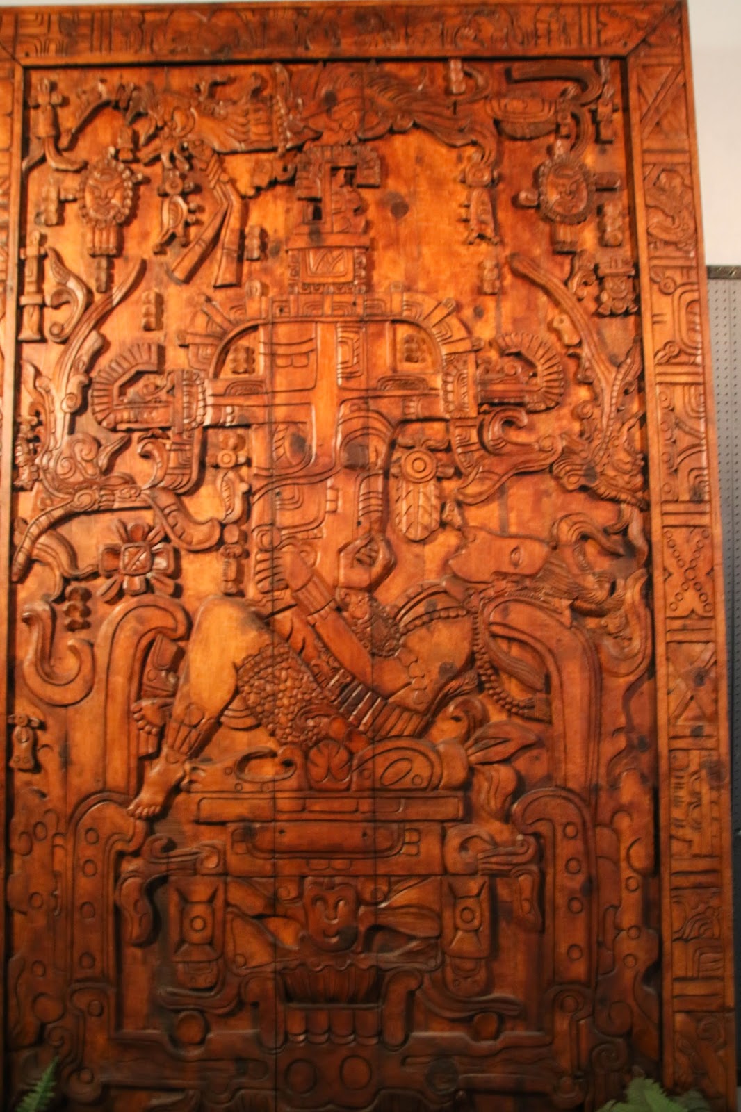
The original crash site is 75 miles northwest of Roswell. The land is privately owned and now closed to people going there as there was too much vandalism for the land owner.
The stores in and around the UFO Museum all have the "alien theme".


We ended the morning going for lunch at the Cattle Baron Restaurant. With seeing all the cows in New Mexico, Ray and I decided we needed to try it. We were pleased with our meals and the price is reasonable. I had a 6oz Prime Rib (looked like a 10oz from the Keg) for $12.95 and paid $3 more for the salad bar. Ray ordered the Rib Steak. We were both happy with our meals. The restaurant has a western theme and is well-decorated. New Mexico's liquor laws are a bit archaic and apparently there's a problem with underaged drinking. So........... how do they solve this???? By ID'ing everyone ordering liquor... yes even at 60 you get carded, rather stupid.
 |
From Google |
Sunday Oct 30th
Another gorgeous morning. Today we decided to visit the Bitter Lake Wildlife Refuge. This area was created around some more sink holes next to the Pecos River. A lovely day for a drive and we took a short trail with Freya.


Another lovely adventure. Time to go home, have lunch, and enjoy the warm weather outside for the afternoon.
Forgot to mention that on the highway down from Santa Rosa Lake we almost ran over a large tarantula spider crossing the road that looked just like this picture!

Forgot to mention that on the highway down from Santa Rosa Lake we almost ran over a large tarantula spider crossing the road that looked just like this picture!


