Monday, Oct 10th
Happy Canadian Thanksgiving!
Today we woke to sunny skies after yesterday's rain and thunderstorms in the afternoon. With the laundry mostly caught up we decided to take another run into the park and visit the Step House on the Wetherill Mesa. The road to this house is quite long, about 12 miles with fabulous views including being able to see Shiprock in New Mexico in the distance.
 |
| Lovely fall colours with new snow on the mountain in the distance. Ray has been unable to get some sunrise shots yet as it has been cloudy in the morning when we get up so maybe Wednesday or Thursday morning he will have success. |
 |
| Some of the ruins across the canyon. You start knowing where to look. Anywhere there is an arch in the rock usually has remains of a housing community. This was zoomed way in to see. |
 |
| Another view from the top of Wetherill Mesa |
 |
| Another set of ruins we noticed that was not marked. |
 |
| Shiprock New Mexico in the distance |
There was lots of "evidence" on the roads of the wild horses that hang out on this mesa but we unfortunately did not see them.
Once we arrived at the parking lot for the Step House trail, we fortunately took the right path as we only had to walk a short distance and were able to view it from the trail. There is a one mile trail that goes all the way around so we were glad we took the right fork trail ... no signage to indicate which way??? There does not appear to be much left of the structures so we didn't continue the hike.
Next it was back to the Top Mesa Loop to get to the Soda Canyon trail, to walk 3/4 mile down (and 3/4 mile back) to the Soda Canyon and the overlook to the Balcony House. This drive was about 20 to 30 minutes from the Wetherill Mesa. We first ate our lunch at the Soda Canyon parking lot before we starting our walk. This trail is fairly easy with little elevation gain through a "Pygmy Forest" of Pinyon Pine and Utah Juniper.
When viewing the Balcony House (which is quite small compared to the Cliff Palace) we were kind of glad we did not bother with that tour ... especially since you seem to only be able to see one part of it while the Park Ranger talks to you for 40 min. Ray and I could see all the people standing in the ruins from the overlook.
 |
| This shows the "100 foot" ladder (bottom right) you have to climb to access the site, 2 people side by side at a time. The park ranger is sitting on a rock to the right above the people and they all just stand there listening to him talk. I never saw anyone access the left side of the ruins, so not much walking around once you get up there. |
 |
| The canyon view to get a perspective on how they had to climb down to the house. |
 |
| A lovely warm day of about 68 F. |
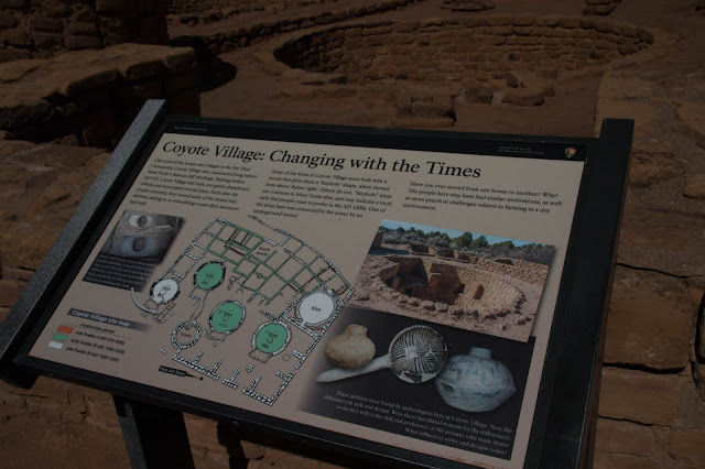
Driving back towards the exit, we stopped at the Far View Community Site again, to finish the walk through the sites. Down a short walk, we saw the Coyote House which was estimated to be built in 975 AD, 200 years before the cliff dwellings. Very interesting. It was one of the most complete ruins that you could walk around inside (although not a cliff dwelling) and get a good idea of what the rooms were for. Originally these would have all had roofs above the structures.
 |
| A kiva with drying racks for meat? |
 |
| Storage bins for dried grains inside the first pit. |
 |
| Entrance to the kiva from one of the living/sleeping rooms. |
Next down the trail is the Mummy Lake
 |
| Love those fall colours. |
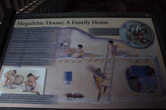
This next ruin shows us the size of a family home with the example of the stones standing up (Megalithic) instead of laying down in rows.
The final ruin (today) is the Far View Watchtower.
 |
| This shows the ventilation hole for the kiva where they cooked and dried their meat and vegetables. |
The last two examples of ruins on this circle tour we saw 2 days ago, the Far View House and the Pipe Shrine House, are in the previous post.
Once back home Ray walked Freya while I started the preparations for our little Thanksgiving Dinner. Awesome Day.


No comments:
Post a Comment