Up fairly early, dumped (the coach that is) and took on fresh water before leaving Lewis and Clark Caverns Campground and on the road by 9:30 am. It's only a 2.25 hour trip to our next destination which is Baker's Hole National Forest Campground, a short drive from the west entrance to Yellowstone National Park. We chose this campsite as it is outside the National Park so the dog can walk the trails as noted by Nina and Paul in wheelingit.us , whose blog we use a s a resource for "paw friendly places". We left a 4200' elevation and are now at 6500' elevation. A balmy 50 F. and wind when we reached the campsite. Out come the hats and gloves again. :)
Mostly cloudy for the way down Hwy 287 to the Hwy 191 Junction. We stopped for a few pictures here and there along the way as the Madison River Valley is absolutely huge and beautiful. We followed the river for quite a few miles before reaching the junction.
 |
| Look at all the snow we missed. Panoramic view of the Madison Valley. |
At the junction of Hwy 287 and Hwy 191 ww carried on through the town of Ennis and Ennis Lake.
 |
| Coming into the town of Ennis |
 |
| Ennis Lake |
Earthquake Lake
This article was published on Aug. 16, 2009, on the 50-year anniversary of the Hebgen Lake earthquake.
A night of tremors, terror
The chain of events began at 11:37 p.m. Aug. 17, 1959, when two blocks of the Earth's crust north of Hebgen Lake dropped over existing faults, setting off an earthquake measuring 7.5 on the Richter scale.
Waves on the waters
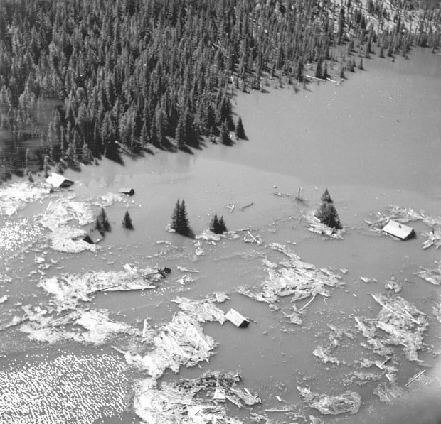
The drop caused Hebgen Lake's north shore to tilt downward, sending lakeside cabins into the water and flooding parts of Highway 287. It raised the south shore so much that docks once lapped by water stretched across dry beach.

Tidal waves of water sloshed across the lake and crested Hebgen Dam. Although the quake cracked the dam, it didn't give way as some feared it might.
The most dramatic event unleashed by the quake was several miles to the west near the narrow mouth of Madison Canyon.
The quake cracked dolomite underpinnings of an unnamed mountain, sending 80 million tons of rock rushing down over the river and the west end of a campground and partway up the other side of the canyon, damming the Madison River.
So much rock fell in a few seconds that it created near-hurricane force winds that would kill and injure several people and beat camp trailers and cars into twisted wreckage.
The survivors soon were confronted with rising water as the river began backing up against the landslide.
Cut off
Those trying to flee in their cars found their way blocked by a highway that disappeared into floodwaters or dropped off over broken pavement.
Nineteen people were thought to have been buried at the undeveloped western end of the Rock Creek campground. It would take weeks to piece together stories from families of missing vacationers to indicate that they were probably caught in the slide.
The developed part of the campground now lies under Earthquake Lake, formed when the Madison River backed up behind the slide.
At the Cliff Lake campground west of Hebgen Lake, a man and his wife were crushed to death by a large boulder that crashed down them where they slept. The boulder missed the man's three sons sleeping nearby and a picnic table full of food.
Five more bodies - four from a single family - were found near the slide. Two people who initially survived later died at a Bozeman hospital.
Through the long night and into the next day, survivors were cut off from the outside world.
Fear of flooding
Worried that the quake might have damaged Hebgen Dam and could flood Ennis downstream, authorities evacuated the town.
The quake, with its epicenter about 9 miles north of Hebgen Lake, was felt as far away as Seattle and caused damage in West Yellowstone, Ennis and Virginia City.
In Bozeman, bricks shook loose from Montana Hall on the Montana State College campus and chimney tops of homes along South Willson Avenue.
In Yellowstone National Park, the quake collapsed a fireplace and chimney at Old Faithful Inn, sent rock slides across several roads and altered hot springs and geysers. After the quake, the average interval between eruptions of Old Faithful increased by a few minutes.
To prevent water backing up behind the slide in the newly named Earthquake Lake from eroding the natural dam and flooding Ennis, a channel was cut through the slide to start the Madison River flowing again.
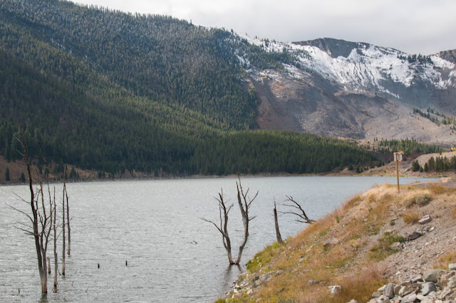
Here is a view of Earthquake Lake across from the Visitor's Centre. See the mountain missing a whole bunch of rock?
 |
| Earthquake Lake |
 |
| All the dead trees left standing from the creation of the new lake. |
Next picture is Hebgen Lake. The lake that tilted 20 degrees after the quake.
We were all set-up in the campsite by noon, had a bite to eat and then it was off for a walk along the Madison River adjacent to the campground. Freya had a great time. Large campsite back-in with 50amp $23/night. Not bad.
 |
| View from our river walk with Freya. |
Athough we do get cell service here with the booster. It is not very fast and uploading pictures is painfully slow. I may not do much blogging until after we leave here.


Thanks for the dog friendly tip about wheelingit. I follow them but didn't connect the dots on the dog thing.
ReplyDeleteAll of their campsite reviews rate the "paws".
DeleteInteresting earthquake story!
ReplyDeleteYa ... we hoped we did not "blow up" while visiting.
DeleteStayed at Bakers Hole for the summer of 2009 while working at West Yellowstone airport refueling fire fighting airplanes.....a great place to be.
ReplyDeleteLoved the campsite. There were lots of fisherman staying to fish the river too. Great little spot.
Delete