Monday morning, we left the beautiful Wine Ridge RV Resort in Pahrump to travel a whole 45 minutes down the highway to a little town called Tecopa, California. This little town is in the middle of nowhere with no scenery to speak of ... a pretty desolate place. What is does have is natural hot springs. There are four different resorts. The resort we chose ... and I use the word resort very loosely, is the Tecopa Palms RV Resort, due to its great reviews. Pros, it had 50 amp service, which is good because the temps overnight have been very cold, free WIFI, good because no cell service in the area and two private bath houses where you shower first and then enter the hot pool naked to soak all your cares away. The facilities are very clean and quite spacious. They also have a very nice clubhouse where they have happy hours every day at 4pm. The Cons, middle of nowhere, no cell service and pretty ugly surroundings and only crusty salty ground to walk the dog, on other than the side of the road (very little traffic though). We booked for 3 days so Ray can soak his sore back to his heart's content.

 |
| View out our front window. |
 |
| View of the front of the bathhouse |
 |
| Vestibule of bathhouse |
 |
| One of the two private baths with shower to the right of the screen. |
Nearby is the China Ranch Date Farm to explore and the small town of Shoshone where there is an old miners community called Dublin Gulch for us to check out. Also if you wished, we are not far from the south entrance to Death Valley National Park.
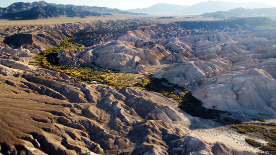
Tuesday morning we were out the door by 9 am on our way to the China Ranch Date Farm. It's only about 15 minutes away but wow is it ever down in a valley. The Armagosa River that starts in Beatty Nevada runs mostly underground until it appears at the south end of Death Valley and it comes above ground at the date farm.
"The Amargosa River is an intermittent waterway, 185 miles long, in southern Nevada and eastern California in the United States." (Wikipedia) Although they call it a river ... it resembles a ditch most of the time. The wash through the valley however, speaks to when heavy rains come and it floods quite a large area.
 |
| Picture from Google ... we would have had to climb way up a mesa to get the same shot. |
 |
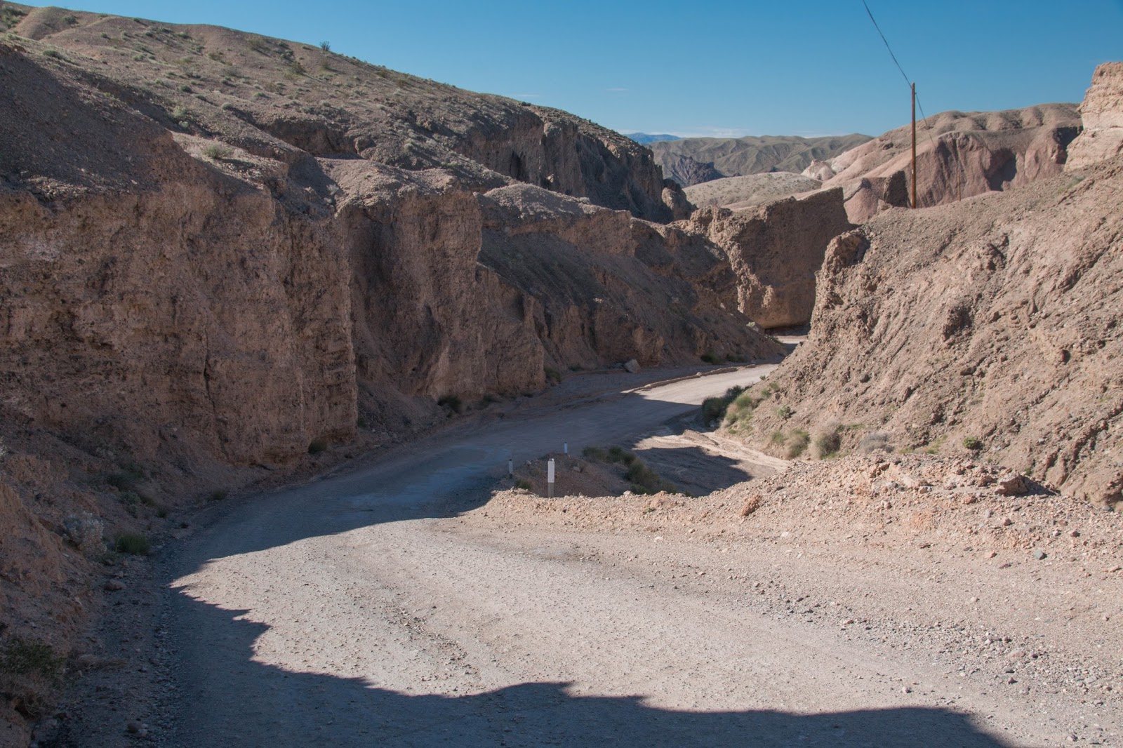
| The very narrow steep road down into the canyon. |

 |
| Their cactus garden. |
 |
| The old schoolhouse. |
 |
| Gift Shop and Bakery. |
There is a trail from the China Ranch Date Farm, the Amargosa River Trail is 2 miles down to the falls. We did not go as it is a 4 mile round trip for Ray but here are some pictures of what we would have seen, especially since Death Valley received in the last 2 weeks the yearly alotment of rain. Oh well, I am sure our good friends
Steve and Dianne may take this some day and show us all the other pictures we missed! lol

 HISTORY OF THE CHINA CREEK DATE FARM:
John Fremont traveled on the Spanish Trail in the spring of 1843, on his way east after heading a reconnaissance expedition to California. On April 29 he passed the confluence of China Ranch Creek and the Amargosa River, about 1 mile to the south. Although his expedition did not come up this canyon, he notes it in his journal. Two days before two of his scouts, Kit Carson and Alexis Godey, traveling in advance of the main group, had shot and killed two Indians here in China Ranch Canyon. The Indians had been involved in a raid at Resting Springs in which two Mexican men had been killed, two women carried off and several dozen horses stolen.
 The Amargosa River, a green ribbon of life flowing an easy 1 mile walk from China Ranch. This beautiful riparian corridor is critical to wildlife and plants in the region as it winds its way into the very bottom of Death Valley (Ray and I wished we could have seen this.)
During the fall and winters of 1849 and 1850 dozens of parties of 49'ers bound for California gold fields used the trail, and their journals contain numerous notes about the Amargosa Canyon. Although this route took them far to the south of the gold country, it was warm enough not to present the risk of freezing to death, as the story of the Donner party was already well known.
Little is known about activities or people here at China Ranch from 1850 until the turn of the century. According to available sources, a Chinese man named either Quon Sing or Ah Foo came to this canyon after many years of work in the Death Valley borax mines. He developed the water, planted fruits and vegetables, and raised meat for the local mining camps. It became known as Chinaman's Ranch. Sometime in 1900, a man named Morrison appeared, and, as the story goes, he ran the Chinese farmer off at gun point and claimed the Ranch for his own. Morrison eventually sold out, but the name had stuck. Since then the canyon has had many owners and worn many different faces, including a fig farm, cattle ranch, hog farm, alfalfa farm, and others. In 1970, the property was purchased by Charles Brown Jr. and Bernice Sorrells, the son and daughter of area pioneer and long time State Senator Charles Brown of Shoshone. It remains in these families today.
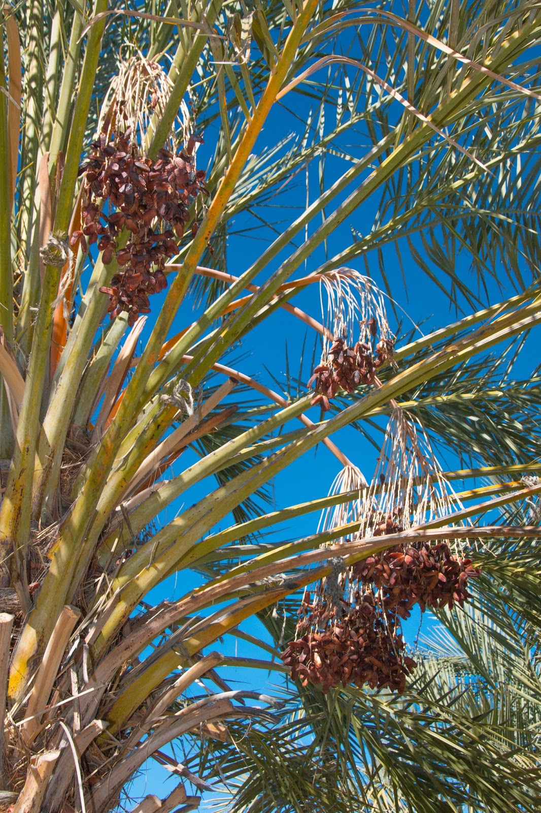
We walked through the date farm and managed to scare up a coyote. Freya was none too impressed. It was eating all of the fallen dates on the ground and judging by all the scat had been doing it for awhile. The orchard had been picked only 2 weeks earlier so we bought some dates for Ray's mom and a bag of baking dates for me (a mixture). They sure tasted yummy.
We left about an hour later and headed back to camp to drop Freya off. Back at the top of the hill we stopped for a few more pictures from the viewpoint. All the way up the road there is evidence of the gypsum mining. There used to be a rail grade down to the bottom to collect the gypsum and then travel back up the very steep grade to connect with the main rail line (until a major accident killed a fireman). Gypsum was used for talc powder and plaster, mostly sent to the growning town of San Francisco.
 |
| South entrance to Death Valley National Park |
Our next destination is the natural hotspring just north of town. We viewed pictures and managed to find the trail to walk in. There were 2 guys enjoying the spring ... told them to "not" stand up we were just taking pics of the top of their head to show people using the pool.
 |
| Once I saw the sign regarding the "mud mites" I decided to use the private pool instead! |
 |
| Grimshaw Lake across the street from the hotspring ditch. |
Next up was the little town of Shoshone about 5 miles up the road towards Death Valley. A town of 31 full-time inhabitants including the Sherriff. The town consists of an elementary school, motel, RV Park, cafe/saloon, gas station, small convenience store, and the Post Office and Town Office sharing a building. One of those towns you blink and you have missed it! Our primary goal was to see Dublin's Gulch, the historic miners town just behind the post office. The miners built their homes into the mud hills in the gulch.
Yes the sherriff still uses the old building on the right.
 |
| Charlie Brown finally made it! |
 |
| A fishing lake we noticed by the elementary school. |
Next up was "Dublin Gulch"
In the 1920’s miners carved residences in the clay cliffsides, since building materials and budgets were in short supply. There are many dugouts on both sides of the gulch, some have chimneys, doors, even split levels and a garage. The gulch may have been named by resident Jon Vollmer for area near Butte, Montana where he once lived. Another group of dugouts is located just east of Shoshone near the Amaragosa River along highway 178 and includes Harvey Rutledge’s Castle in Clay. Nobody has lived in Dublin Gulch since 1970. Similar dugouts can be found along the China Ranch road in Tecopa, and near Lower Noonday Camp. (Google)

 |
| This was a car garage. |
After visiting the town office, Ray was able to find out where the Castle in Clay is ... a short distance up the highway back to Pahrump where the Amaragosa River crosses under the road.
 |
| Castle in Clay. |
 |
| The Armagosa River before it goes under the highway from Pahrump. |
Although we saw a lot, everything is within 15 minutes from the campsite. Another great adventure comes to an end.
Wednesday morning wer're being very lazy. Me with the blog and made a big breakfast and Ray with the pictures and dog duty. Then it was time to shower and use the bathhouses again. A rest day before we leave tomorrow for hopefully Afton Canyon BLM campsite.


The clay dwellings were very cool, that would have been interesting to see. Good call on passing on the mud mites area, that sounds like it could be painful!
ReplyDelete