Warning ... picture overload. lol
Sunday, another beautiful sunny
day. We hit the road by 8:45 am for our short journey to another National Park,
Black Canyon of the Gunnison. By 11am we were all set up at the campground in
Loop B, the electric loop. (50 amp service, no water) Fortunately, we came early as there are only 3
campsites available that would fit us. As it turned the next day they shut down the other 2 loops so everyone scrambled for a campsite here.
.jpg) |
| Nicely tucked in. |
.jpg) |
| Our campsite area behind the coach. |
The drive up to the park is a very windy, steep, 7 mile road up to the top of the canyon. Definitely a slow drive with the motorhome towing the car.
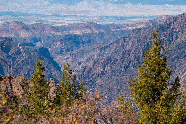
Black Canyon of the Gunnison National Park is in western Colorado. It surrounds part of a deep, steep-walled gorge carved through Precambrian rock by the Gunnison River. Roads and trails along the north and south rims have views of the Black Canyon's dramatic drops and the striated Painted Wall cliff. The winding East Portal Road descends to the river. Wildlife includes mule deer, elk and golden eagles. ― Google
About 30 million years ago, large volcanoes erupted on either side of this uplift, burying it in volcanic rock (blow). Then, as early as 2 million years ago, the Gunnison River began flowing in force (flow). The river and time eroded all the volcanic rock and cut a deep canyon in the metamorphic rock below.
After having a bite to eat, we
headed out on the South Rim Drive, a 7 mile drive total. The canyon is so deep that it's a good
time to go around noon, so the sun actually lit up the canyon. Most of the
overlooks required a bit of a hike from the road to the lookout. (About 1/3 to ½ mile up and down over well-groomed trails.)
After a couple of hours of driving and hiking, we came back to the Motorhome for a rest. At 4:30 pm Ray headed out again for some sunset shots but found the canyon is way too dark already. Difficult to photograph. He tried again Monday morning early and then came back and got me and we walked 3 more lookouts starting at 9am. Here are the “chosen” shots over the past 2 days. Hard to pick as they were so gorgeous. What a great place to visit. The only downside is almost no cell service even with a cell booster.
I put the pictures in the order of the Rim Drive.
TOMICHI POINT
.jpg) |
| Looking down at the Gunnison River |
GUNNISON POINT AT VISITORS CENTRE
This is so awe inspiring, Ray took a video.
DEVILS LOOKOUT
Devils Lookout looking over to the North Rim lookout, the Narrows view. It takes a long time to get to the North Rim Drive, accessed through Curecanti National Recreation Area. It is a dirt road only 6 miles long. We opted not to go that way.
CHASM VIEW
CEDAR POINT
DRAGON POINT
SUNSET VIEW
HIGH POINT
Monday after we got back after relaxing for a bit it was time to put together our Thanksgiving Dinner. Instead of turkey, I am cooking a big stuffed chicken instead with the fixin's. :)
Quite a bit cooler today at 62F. A good day to have the oven on. 😊 Tomorrow driving through the Curecanti National
Recreation Area on Highway to Salida. CO.
The only wildlife we came across isa few bunnies and a deer on the way out of the park.
.jpg)
.jpg)
.jpg)
.jpg)
.jpg)
.jpg)
.jpg)
.jpg)
.jpg)
.jpg)
.jpg)
.jpg)
.jpg)
.jpg)
.jpg)
.jpg)
.jpg)
.jpg)
.jpg)
.jpg)
.jpg)
.jpg)
.jpg)
.jpg)
.jpg)
.jpg)
.jpg)
.jpg)
.jpg)
.jpg)
.jpg)
.jpg)
.jpg)
.jpg)
.jpg)
.jpg)
.jpg)
.jpg)
.jpg)
.jpg)
.jpg)
.jpg)
.jpg)
.jpg)
.jpg)
.jpg)
.jpg)
.jpg)
.jpg)
.jpg)
.jpg)
.jpg)

Another amazing area! Great pictures.
ReplyDeleteWe were just "gob smacked" by the depth of the canyon.
DeleteWe have heard a lot of great things about the Gunnison area, even though we are only 500 miles away we have never been there. We have plans to maybe get that way next year! Love all your pictures, you picked the perfect time of the year to go there.
ReplyDeleteYes we did. The weather has been great and the fall colours fabulous.
DeleteI would hate to have to climb out of that canyon, wow! Kristi
ReplyDelete